 Custom Search
Todays walk is a circular taking in a section of the Southern Upland Way( SUW ).We were programmed to do this back at the beginning of December,but the big freeze meant it had to be put back.
This is a new walk to me.
Five cars carrying nineteen walkers took the winding potholed track to the walk start west of Derry farm and close to Loch Derry.
It's quite overcast today.


.

I need the break we have at the top.There's all round long distance views from up here.The nearly commissioned windfarms at Arecleoch and Markhill are prominent.


They're certainly different to other holy wells I've come across
Here's what Canmore has to say.
Archaeological Notes
NX27SW 2 2297 7232.
(NX 2296 7231) Old Kirk Yard (NR).
OS 6" map (1957)
(NX 2298 7232) Wells of the Rees (NR).
OS 6" map (1957)
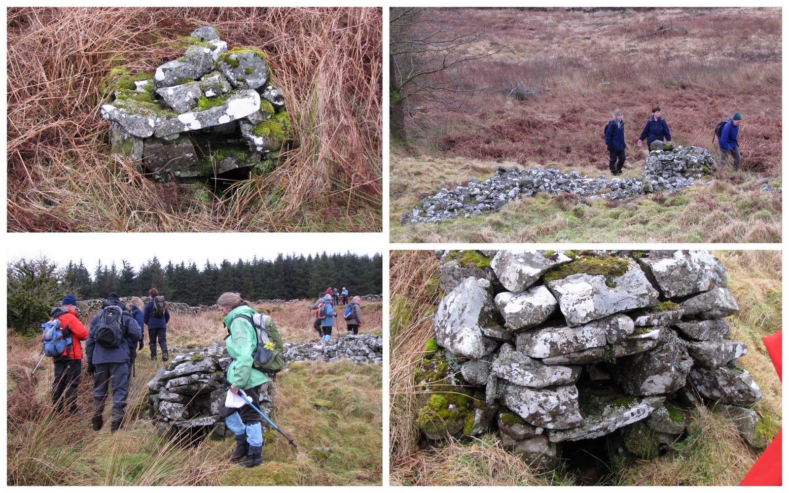
The site of the church of Kilgallioch of whose history nothing is known. The churchyard is a small patch of raised ground surrounded by the foundation of an old well. There are no grave-markers.
The Wells of the Rees, so named because of their proximity to sheep rees said to have been built from the fabric of the old church, are three springs covered by domed structures of large unmortared stones circa 3 ft high with square openings at ground level with, above lintel a recess 1 ft 2 ins square and 1 ft 3 ins deep. The best preserved of the three is oblong 6 ft long by 4 ft.
They are traditionally said to have been resorted to by penitents for religious ceremonies etc. McKerlie found them reminiscent of the domed wells in the vicinity of St David's, South Wales. The name Kilgallioch is said to be a corruption of Cill na Cailleach - the Nun's Chapel.
RCAHMS 1912, visited 1911; Name Book 1846; E M H M'Kerlie 1916
NX 2297 7232 The site of this church appears as an 'island' of dry, relatively high ground, bounded on the N and W by a semi-dry watercourse and on the E by a modern field dyke. An old wall can be traced around the perimeter of this rise but there are no other remains to be seen. The three springs are covered by crudely built stone domes and are described in the previous information.
Surveyed at 1:10 000.
Visited by OS (BS) 17 February 1976
(NX 2296 7231) Old Kirk Yard (NR).
OS 6" map (1957)
(NX 2298 7232) Wells of the Rees (NR).
OS 6" map (1957)
The site of the church of Kilgallioch of whose history nothing is known. The churchyard is a small patch of raised ground surrounded by the foundation of an old well. There are no grave-markers.
The Wells of the Rees, so named because of their proximity to sheep rees said to have been built from the fabric of the old church, are three springs covered by domed structures of large unmortared stones circa 3 ft high with square openings at ground level with, above lintel a recess 1 ft 2 ins square and 1 ft 3 ins deep. The best preserved of the three is oblong 6 ft long by 4 ft.
They are traditionally said to have been resorted to by penitents for religious ceremonies etc. McKerlie found them reminiscent of the domed wells in the vicinity of St David's, South Wales. The name Kilgallioch is said to be a corruption of Cill na Cailleach - the Nun's Chapel.
RCAHMS 1912, visited 1911; Name Book 1846; E M H M'Kerlie 1916
NX 2297 7232 The site of this church appears as an 'island' of dry, relatively high ground, bounded on the N and W by a semi-dry watercourse and on the E by a modern field dyke. An old wall can be traced around the perimeter of this rise but there are no other remains to be seen. The three springs are covered by crudely built stone domes and are described in the previous information.
Surveyed at 1:10 000.
Visited by OS (BS) 17 February 1976


Another half a kilometre brings us to where we'll stop for lunch.Now I know why it's called the Beehive Bothy.

It's basically a shelter for bad weather,but it's certainly well constructed with solid seating around it's interior.Our walk leader reads out her previous entry in the visitors book.We split into two groups (outdoor and indoor) for lunch.

Here we split into two groups for those wanting to take a look at the ruined buildings at Killgallioch.

One particular rambler,once of the farming community seemed to think he'd visited here while it had been a working farm.
I spotted a large lintel that may have once been one of the Laggangairn standing stones.
The dampness in the air was now turning to drizzle.


A lot of historical stuff included made this a very interesting walk.
Back in Newton Stewart a fair number of walkers enjoyed tea,scones and a natter at the Cinnamon cafe.
I'll finish this post with the picture below,although I don't really know why.
Thanks Scoop !


Excellent, there's rewards in them thar hills for those who dare to leave the road.
ReplyDeleteIt's quite a fascinating area Sandy.
ReplyDeleteIn addition there's Purgatory burn which goes back to the middle ages and a Leper colony at Liberland (Leper Land)near Derry farm,lots of cairns (I'd guess Hoodie Cairn got it's name from the crow rather than the youngsters of the time)and a name that makes me think of the Coldstream Guards....DrummieMickie
Jim, great photos, this walk looks fascinating, i really want to do it! I should love to see the wells & standing stones.How long did it take to do this walk? We did a lovely walk last week around the gray mares waterfall area, some wonderful sculptured heads to find there. ps thanks for visiting my blog & your words of support. greatly appreciated.
ReplyDeleteLooks like a great location you folks went for your walk! Great pictures, even in the misty weather. You put your blogs together quite well!
ReplyDeleteMore often now I've been doing hikes & need to get some new gear, better footware, new backpack, etc...
Michael
Hi Ruthie,we did the round trip in about 4 hours.
ReplyDeleteTo shorten it,it's possible to walk along a forest track to the wells without climbing Craig Airie Fell.
The Mare's Tail walk is lovely,I think there are moves afoot to update the 'Art in the Forest' project with some new exhibits soon.
Boots are often my problem Michael.I've bought expensive footwear in the past lasting less than 12 months,and cheaper ones still on the go.
ReplyDeleteOk, they usually come with a guarantee,but by the time you pay the postage and fill out the forms and all you get is a money off voucher for your next pair,it's not worth bothering with.