 Custom Search
Saturday August 17th 2013
Today's walk is in the South Rhins with the walk start at North Milmain, Stoneykirk.
Today's leader is the 'Weaver' with 'Wheels' as her backup.
Her report will be after the photographs.

It's raining as our walk leader explains the route, but as soon as we started walking it stopped.
Seventeen of us set off but we'll be up to twenty at the walk finish.

We're heading north east. There's a lot of sheep about.

Crossing what might be the Stoneykirk Burn.

A recently harvested barley field

Somewhere around Mosscroft

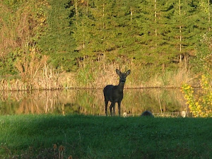
The geese were just taking off as my camera clicked.

A couple of agricultural machines somewhere around Low Mye

Old route to Clayshant from Stoneykirk.

Approaching Culmore, this is 'Wheels' patch.

The above collage of pictures look much better in inverted colours.

A short road walk from Culmore to Culmore Bridge

The owners of Culmore Bridge Cottages are also ramblers and had kindly allowed us to walk around their woodland paths and wildlife ponds. The ponds are home to the protected Great Crested Newt.

There's a comprehensive notice board by the ponds.

A water lily.

Reaching Sandmill

We'll be heading up Balgreggan Motte

It's a short but steep haul to the top.

The views would be extensive on a better day.

A happy bunch.

Just west of the motte was where an archaeological dig had determined the original Sandhead village.

In the woods behind this diagonal feed fence once stood Balgrennan House a large country house, seat of the Maitland family.

A gate requiring patience and perseverance.

Next to the Balgrennan curling pond, the hut for storage of curling stones still appears in reasonable condition, which is more than can be said for the pond itself.

Balgreggan Farm.

Ballochalee Glen

One time water supply for Sandhead.


Lunchtime.

Horses at High Culgroat.

The sun makes an appearance.

Another wind turbine ready for erection.

Passing through Low Culgroat.

Some nice signs and walls.

Another short road walk to Glenpark.

Now began the farm tour. Milmain is a crop farm and we were to be shown much of the layout and the crops grown.

Across a tributary of the Culgroat Burn.


Climbing Milmain Hill.

Views across Luce Bay.

It's a straight road to Stoneykirk, but not for us.

Fields of oats, barley and wheat were seen.

Oil seed rape was looked at close up.

Back at the farm............................

......................and storage of the crops.
(Tea, coffee, scones, butter and jam finished off a great walk.)
Ramblers’ walk August 17th 2013
Seventeen ramblers met on Saturday at North Milmain , Stoneykirk, for an 8 mile farm walk in the surrounding area. It poured with rain as they got out of their cars and then, miraculously, stayed dry until the walk was finished.
A track ran through wheat fields and across a water splash to then cross a potato field in the process of being lifted. Some of this field had been down to barley which was harvested before being completely ripe to go for whole crop animal feed. The walkers now reached the road, following a section of the coast path and causing a flock of geese to lift off and circle overhead. A wide track led through a still standing barley crop, to an old overgrown route to Clayshant from Stoneykirk. This was the way to the ancient Clayshant church and churchyard which was replaced by the Stoneykirk church, which again was rebuilt in 1827. This church is now sadly disused, the tower seen as a landmark back in the village.
After crossing Culmore Burn, a well-kept path around holiday units for the disabled led to the site of the old Clayshant tile works. The ponds are now a natural habitat for newts, whirlygig beetles, waterboatmen, and other pond life. Another rambler now joined the group. A grassy path round the ponds took the walkers to Sandmill Bridge and the footpath along to Balgreggan motte on the ridge above the A716. This is the first in a series of mottes along the east coast of the Rhins. The ramblers scrambled to the top of this early castle to get a wide view of Luce Bay which was somewhat diminished by low cloud and distant mist. Lumps and bumps in the field below showed where the original village of Sandhead was situated.
The walk now proceeded to view the old Balgreggan curling pond and clubhut, before crossing fields to a ruined cottage and Ballochalee glen, where the remains of Sandhead water works were still visible. A pretty waterfall and burn captivated the walkers and a lunch stop was provided by a hidden gem of woodland and rocky outcrops.
Soon after passing fine Aberdeen Angus cattle in fields around Culgroat the group were joined by the farmer at Milmain to give a tour of arable fields and explain his farming practices. There were now 20 walkers. He showed oil seed rape ready for harvesting to provide rape oil, oats which are sent to be processed for porridge, barley which is generally for local cattle feed, and wheat which is made into alcohol and also used a pheasant feed. The weather had now improved a little and the view from Milmain Hill was wide and spectacular, where the progress of the whole walk could be plotted out.
The weary ramblers at last arrived back at North Milmain farm where they were shown crops already harvested and then suitably refreshed by a welcome tea.
Next week’s walk is a 9 mile ‘B’ circular tour of Maxwellston Hill at Dailly. Meet for car sharing 9am Breastworks, Stranraer, 9am Riverside, Newton Stewart or 10am Dailly Square War memorial, NS 270 016. All are welcome but if going to the start of the walk or if a new walker, please phone walk leader, 01456 712180.


What a fabulous walk! Love the scenery! How nice that the geese were just taking off as your camera clicked!
ReplyDeleteLovely photographs as usual Jim. I bet you cover twice as much ground as the main group to get them all.
ReplyDeleteThat's why I usually do bike trips on my own nowadays. I'm either stopping for a shot every five minutes or thinking 'if I go over there that's a better angle.'
Bet you,re always catching them up, walking ahead or taking detours off to the side:)
Often wandering about the area there are little things like Balgreggan Motte. Little reminders that not that long ago people the country was a completely different shape and people lived in completely different places. These motte and bailey arrangements don't go nearly as far back in history as a lot of the things we see in the countryside.
ReplyDeleteLooks like quite an autumnal walk, at least there is tea and scones at the end - I applaude you civilised closing practices.
glorious shots---love the back story on the lost village!
ReplyDeleteI was lucky with the geese Linda, the camera was on a 'sports' setting at the time.
ReplyDeleteAye Bob, I often go off at a tangent. It works for me sometimes though, for example I see the group going down just to climb again and I stick to the high ground.
You're right there Sandy, the dynasty of Fergus only goes back 900 years or so while the stones at Cairnholy are at least 4000 years in place.
Thanks Lynn, we might not have too many mod cons here but we have history.