Day 7 Afternoon
Tuesday afternoon .
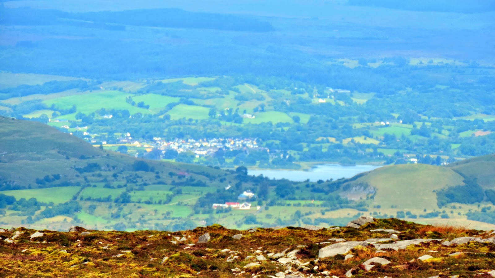
This is another view of Lough MacNean.
I went to visit friends Philip and Mary, and spent the day with them.
Philip has been diagnosed with a serious disease and is having chemotherapy.
Mary cooked sumptuous T bone steaks, Philip has a great appetite and a great attitude to his illness.
It was a lovely evening as we walked off our dinner with a circuit of the FlorenceCourt Estate.
Anyone seeing Philip striding out would think there was nothing wrong with him.
I'm sorry I didn't get another visit before coming home. All the best to you both.
Day 8 Cuilcagh
My twin daughters Sarah and Marie, and Sarah's fiance Phil are joining me to climb
Cuilcagh Mountain
The twins have climbed it previously, it'll be Phil's first time.
We start to walk from what is locally known as 'Brian's Hill'.
We head over by the old peat bogs, and follow the river upstream.
Cuilcagh is important in mosses and lichens.
Looks like it got some interesting fungi too.
I took much more macro shots of Cuilcagh's flora and fauna on last years climb.
Scroll down this link for a colourful collection.
The first time I climbed up here, I learned from my father in law about the 'Green Stripe'.
I've been coming up this way ever since even though there are easier ways up.
We're soon looking down again on the wider Glangevlin Community.
A mountain native.
It gets easier on the plateau (not that I'm inferring that Phil is resting, he's enjoying the view)
Sarah and Marie and the wee lough below...............
........................and over thirty years ago their older sisters Michele and Lynn
(Have you two been up since ? Oh yes Lynn climbed it last in 1993)
At 665 metres, Cuilcagh Mountain is the highest point in Cavan and Fermanagh. Its distinctive table-top profile is the dominant landscape feature in a region rich in geology, archaeology, folklore, history and wildlife. The mountain is topped by gritstone, which is exposed in places as dramatic cliffs looming over the upper sandstone and shale slopes. The middle slopes of Cuilcagh Mountain are covered with a thick layer of peat forming one of the best examples of a blanket bog ecosystem in the north of Ireland. Cuilcagh's lower slopes contain Ireland's finest karst or limestone landscapes, which hide many complex cave systems.
A full zoom brings up Lough MacNean and Belcoo.
Spot the raven,I never noticed it while I was taking the picture.
Lots of pictures taken at the summit.
The Triangulation Station was put up in the 1950s.
The sand, cement and aggregate was brought up on donkeys.
The name of one of the builders can still be seen in the spider.
We'll see him back at Dunmakeever.(He's my brother-in-law)
The ten second delay picture.
Now I thought I'd take a panorama.
I'm disappointed that the light wasn't better.
Here are some stretches of water.
Top is Upper Lough Erne.
Below left is Upper Lough MacNean
Below right is Brackley Lake (What looks like an oversized tree is a Crannog in the lough)
We have lunch and just enjoy being up here.
Marie goes walkabout.
In the distance is Ben Bulben, while Keiran O'Conner flies over in his F172N Cessna.
We get another shot of the four of us, and Sarah and Marie add white stones to the ancient track.
Thanks for this picture Marie
In 2008, the UNSECO endorsed Marble Arch Caves Global Geopark of which the Marble Arch Caves are a key site, was expanded to include some of the most scenic landscapes in Counties Fermanagh and Cavan, making it the first cross-border Geopark anywhere in the world.Marble Arch Caves is the flagship attraction of the Geopark and is one of Europe's finest showcaves. Visitors explore a fascinating natural underworld of rivers, waterfalls, winding passages, lofty chambers and a bewildering array of cave formations.Behind the visitor centre is the Marble Arch National Nature Reserve. For a peaceful and relaxing walk, follow the path alongside the Claddagh River. The unique ancient plant life that grows on the river banks changes with every season as does the amazing wildlife with dippers and pine martens being just some of the animals that reside there.
There's a stile along the fence on Bursan, and we'll descend by the old track.
I think we're all a little light headed with the altitude.
I was asked
"Why didn't we come up this way ?"
It was about here we strayed from the track a little.
I always seem to lose it at the same point, yet at the gate looking back it's obvious !
N.B (At this point we had to almost run for our lives.
Billions and trillions of flying ants began emerging from the earth and getting into our clothes, hair and even into body orifii. They were also vicious biters. I still don't know how we survived them.)
Back at Doonmakeever we're treated to our second slap up meal......
...........and below, a farm tour.
We're in unison about one thing.
We've had a great day.

 Custom Search
 Back up the foothills of the Cuilcagh mountain in Glangevlin to the old homestead at Dunmakeever.
 The rolling hills of West Cavan look as lush as ever.
  The requiem mass was well attended,with family coming from far and wide.Even this frog was trying to get into the church.
 But as well as being a sombre occasion,it was also a celebration of his life,and it was good to meet up again with some of the nicest people I know.The immediate family made sure that the extended family were enfolded in the occasion.
 Up from Kildare came a rebel of a musician by the name of Mick Molloy (Not to be confused with Matt Molloy of the Chieftains,though Mick has sung with Kila),accompanied by his missus Rosie.
  I was back early enough to take a run up to Carrickfergus....
 ...and view some of the sights.
 Back in Scotland on a clear day the chimney of the Kilroot power station in Belfast Lough can often be seen.I'm much closer today.
 The Harland and Wolff and other dock cranes show me the way back to the ferry.
 I'm soon back at the quayside.
 As I wait to board the Stena Navigator,I take some more pictures and reflect on my short and poignant trip.