Being the deputy walk leader today,i had to recce the walk with the walk leader midweek.This walk is nowhere as interesting photographically as last weeks,and because of this i'll be including some pictures from the recce.
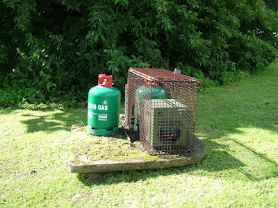
Rendezvous is at the Village Hall at New Luce,and before the group even gathered round,this contraption created a little curiosity.

No prizes for guessing it's purpose,'cause no doubt a few of my readers already know.For those still wondering the answer will be at the end of this blog.

Despite a dodgy weather forecast 26 humans and 1 canine(Curly)gathered for todays walk.A welcome was given by the walk leader to the new faces in the group.

The first two kilometres of the walk is on the Glenluce road,following the course of the Main Water of Luce.

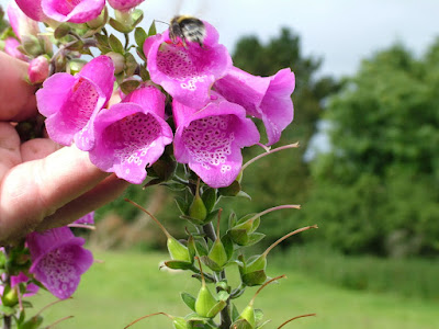
I wonder why foxgloves shed their flowers from the bottom up.
There's not a lot to see from the road along this stretch.I've no doubt though,if you have the time to detour regularly from the route,there'd be plenty to discover.
I've been reading some stuff on the internet from the Antiquarian Society,and in particular a report to the society from 1899 under the heading 'LIST OF THE ANTIQUITIES OF GLENLUCE, WIGTOWNSHIRE, WITH DESCRIPTIVE NOTES. BY REV. GEORGE WILSON, CORR.. MEM.
S.A. SCOT.'
Anyone interested can find this at
http://ads.ahds.ac.uk/catalogue/adsdata/PSAS_2002/pdf/vol_033/33_170_185.pdf
There are Standing Stones,Cairns,Megalithic Tombs,Forts,Rings,Mote Hills etc all around this area,and of course just down the road is Glenluce Abbey,a 12th Century Cistercian Abbey founded in 1190 by Roland, Earl of Galloway.

At Cruise Farm,we join the SUW onto farm track heading north east.

There are a number of stiles to climb on this section...

...and once negotiated...

...a moment's rest.

A member of todays group used to farm in this area.
He remembers Kilhern farm when it was a working farm.

Now we reach the ruins of Kilhern farm.

It appears to have been quite extensive.

More local knowledge is imparted.
While on the recce we'd had a look for 'Kilhern or Spa Well' shown on the ordnance survey map,without any success.

A concrete slab covers this well we found next to the small building shown in the collage above.The water looked beautifully clear.Could this be a bore hole and the original well diverted here?.

Curly's more interested in the woolly creatures in the field opposite.

This being a fairly easy walk,there's no great urgency to make haste.There are lots of stops, discussions and observations today,and the weather's staying clear.

Now it's time to move on,and a change of direction.We're now heading north west.

Here is where we should have been turning towards the 'Caves of Kilhern',but a rather large and somewhat noisy bull in the adjoining gateway meant an earlier detour over moorland.With cows and calves in the adjoining field and a dog in our midst this was probably a wise move.

Another obstacle in the shape of an awkward wooden fence.The wire fence alongside is electrified.Artfield Fell windfarm is in clear view.

What looked like just a pile of stones now takes a definite shape.

The 'Caves of Kilhern' are actually Megalithic Cairns or Cists

Some 4000 to 5000 years old.
Rev George wilson in his 1899 report indicates 8 Megalithic Cists.
More up to date is this from Ancient-Stones.co.uk
The Caves of Kilhern are actually a much-robbed and disturbed long chambered cairn which is overgrown with bracken and heather. It measures some 34.00m long by 20.00m wide at the north eastern end and 11.00m wide on the south west end and reaches an overall height of about 1.70m. The cairn contains the remains of four chambers with indications of a possible fifth.
According to the Rev Wilson the latest dilapidation(in 1899) was caused by Sir Herbert Maxwell uncovering two of the graves.

It's a bit windy and exposed,but as good as spot as we'll get to have lunch.Our walk leaders thoughts are predisposed with avoidance of the uncastrated adult male of the herd in the next field.

Lunch over and another sensible detour.This one may actually shorten the walk slightly.

Here a lovely view of the 'Cross Water of Luce' opens up.

Here a couple of youngsters wonder whats happening.

And here from our midweek recce,a very young calf barely able to stand yet.

The OS names this wooded area as Knockcraven.Besides this small ruin,there are other derelict buildings in the woods.
A number of years ago walking the Cuilcagh Mountain in Ireland with a brother in law,we came across a similar ruin to this one.My brother in law remembered it being occupied by a shepherd,his wife and their two children.It must have measured about 20ft by 12 or 15 ft.Times were hard once.

Another mini break for the back markers to catch up.

And now we're on the Artfield Fell/New Luce road.Just a short walk back from here...

...and the walk is finished.

But a number of todays walkers are enjoying the company enough to take a walk over the 'Cross Water of Luce'...
.JPG)
...to the Kenmuir Arms...
Where banter and refreshments come in equal quantities.
Todays has been one of the easiest i've done.Or am i getting fitter?Time will tell,or not.
The name on the contraption in the first picture gives it's purpose away.It's a Midg-it,specifically designed to combat biting insects,yours for only £470 from Calor(Scotland).
A very enjoyable walk.

 Custom Search

No comments:
Post a Comment
Thanks for all your comments. I may not get to reply to them all, but you may be sure they'll be appreciated.