
 Custom Search
Saturday the 20th December
This walk is in an area we've been countless times. Here's just a couple of links.
Shorty was the walk leader and I'll add his report when I get it.
There'll be a great selection of photographs from Scoop too, I was disappointed I had to delete so many photographs, perhaps I got damp in the camera early on.
We numbered twenty seven for this walk.

It started raining before we set off, showers were forecast.

This lovely deer watched our passing.............

...................but then with it's three companions took off at a fast pace.

Shorty outlining the history of the corn kilns

This area is currently undergoing archaeological digs by the Cree Valley Community Woodlands Trust

Possibly Clauchrie Farmstead

Wood carving by Ross McCredie

At least this burn has a bridge..............

..............subsequent burns proved to be more adventurous


This wee pond doesn't appear to have a name (unless a local reader knows different)

Atmospheric pictures from the ancient cairn to Newton Stewart and Wigtown Bay

Information boards abound
*A note in case anyone from the Cree Valley Community Woodlans Trust reads this. I've heard a number of times now of people driving past the entrance to Knockman because they think the big gates are private. Perhaps a better sign would help !

Some of today's happy walkers.

Douglas Ewart School from Knockman

McMillan Hall from Knockman

Did we have a sweetie stop, I don't remember ? No worries, there'll be lots of after walk goodies in store.

Now then, what have we here ?
An ancient site for some old ritual practices perhaps !

First of the previously mentioned adventurous burns
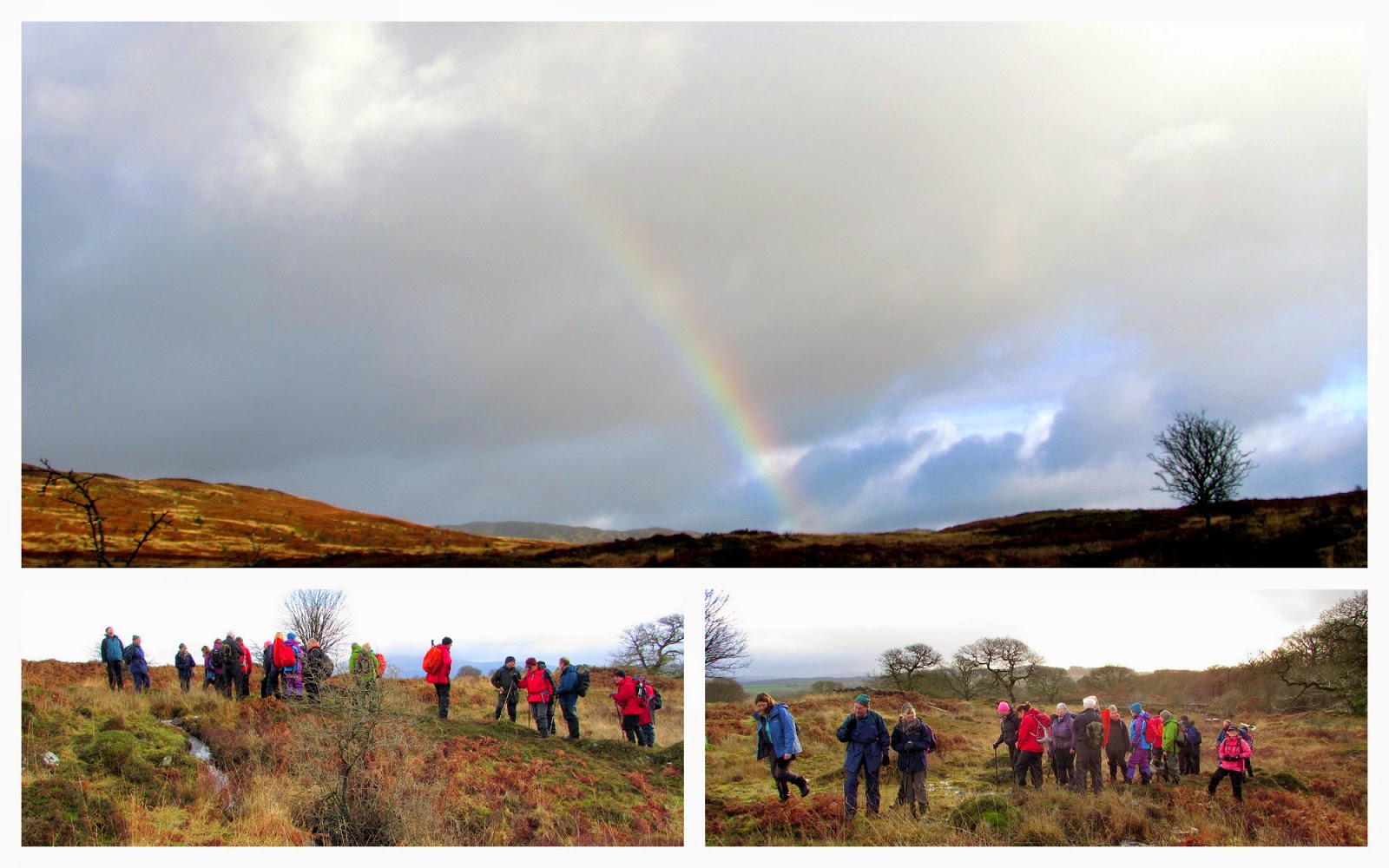
A rainbow arrives as we pass the old ferm toun

We lunched in and around Garlies Castle.

Back on the move after lunch

The Peat Rigg Strand crossing


Avoiding a small deep burn proved impossible for two walkers. They'll have dried out by now.

A previously unwalked (by the ramblers) track.

Torbain Hill Millennium Cairn
A short walk took us back to the cars where clean clothes were donned.
Then it was back to Shorty and A'OK lovely house for their traditional 'Mulled Wine and Mince pies' get together. A wonderful end to a nice, but sometimes damp walk.
Shorty's report will appear here.Wigtownshire Ramblers – Saturday 20th December 2014 – Knockman Wood & Garlies Castle Circular
It started to rain as twenty six ramblers set off from the Knockman Wood car park for a short walk in the neighbouring countryside. The shower passed quickly and we set off along the newly re-laid path past two of the old farming townships and soon reached the third, Clauchrie. Over the past couple of seasons the Cree Valley Community Woodland Trust, with finance from the Heritage Lottery Fund have been carrying out extensive archaeological excavations across the site and, with expert guidance and enthusiastic volunteers have turned up an interesting story of our forebears in this area. The excavations have revealed a corn drying kiln with an attached barn. Carbon dating suggests that this was last used in about 1800. The site is less than 200 metres from the previously known drying kiln – a large investment in a small area, suggesting that damp weather was also a problem back then. There was also the base of a large barn with a partially paved floor, possibly for threshing and, nearby, the remnants of a byre and a 3 roomed long house. A search of the parish records had shown occupation from the early 1600s, with four residents signing the National Covenant in 1638. Numerous births, marriages misdemeanours and payments of poor relief are recorded for the next hundred years or so. Many of the names recorded are still common in this area. Davidson, McConchy, McKie, McKeand, McMillan, Murray, Skimming and Stewart are all represented. It seems that the abandonment of the township coincides with the building of the deer dyke around Garlies and Knockman woods – perhaps an example of clearances or possibly a move to the developing nearby Newton Stewart for an easier life in the mills.
On leaving the fermtoun we climbed past the small lochan and up towards the top of Knockman Hill and soon reached the chambered cairn. Work has been carried out here to clear the bracken around the site and it is now possible to see the structure and setting of the cairn. After examining the site we set off again and, avoiding the track to the summit and Barclye, along the rough track which leads back to Clauchrie around the other side of the shallow valley. There were lovely views towards Newton Stewart and the Cree Estuary basking in the misty sunshine.
On reaching the lower level again we turned off the path and followed the deer fence eastwards until we reached the gateway in the dyke opening onto the Glenmalloch Moor. Here we encountered our first obstacle as we crossed the Castle Burn which was running quite strongly after the recent rain. At this point another member joined us, having arrived at the start a little late he managed to track us down. Careful progress was then made over the various tributaries of the burn until we reached the track leading through another fermtoun... This one seemed more compact than Clauchrie, perhaps because of its more exposed location. Passing through the ruins we crossed a boggy section to reach the gate into Garlies Wood. We soon arrived at the ruins of Garlies Castle where we paused for lunch. As we settled another brief shower passed over. The following sunshine gave us a dramatic rainbow against the dark clouds to the north.
After lunch we descended the bracken slopes to the Peat Rig Strand which was running strongly through the trees. Various techniques were adopted and eventually all members reached the other bank with reasonably dry feet. The track then ascended through the wood and out onto the grazing land at Liggat Hill. We followed the tractor tracks down the grassy ridge to the old road in the valley below. We splashed along the track back towards Minnigaff and soon passed the restored schoolhouse, now a holiday cottage run by the Landmark Trust. They have done an excellent job in restoring the once derelict building which had been built on the instruction of the Countess of Galloway in the1830s to provide training for the girls from the surrounding estate. It had one small schoolroom and accommodation for the teacher in a single room with a loft. It was difficult to imagine how 23 girls fitted into such a small room.
A rough track lead us back to the Garlies Castle roadway. A white fallow deer was spotted near the deer dyke. He watched us for a little while and then took off along the dyke, closely followed by three, more camouflaged, others. We followed the rough road back to Torbain Hill, a low rise with a cairn commemorating the Millennium. From the summit of the hill we again spotted the white deer standing on the moor nearly half a kilometre away.
From the hill we descended to the track and soon reached the cars again, just as another shower started. We then retired to our secretary’s house where she provided us with scones, mulled wine and other goodies to celebrate the festive season.
Next week’s walk will be a leisurely walk in the countryside around Wigtown. Meet at 09:00 at the Breastworks car park in Stranraer or at 09:30 in the Riverside car park in Newton Stewart to share transport. The walk will start from the County Buildings in Wigtown at 10:00. If going direct to the start or for further information, please contact the walk leader on 01988 840268.
PICTURES BY SCOOP
.JPG)
.JPG)
.JPG)
.jpg)
.JPG)
.jpg)
.JPG)
.jpg)
.JPG)
.jpg)
.JPG)
.jpg)
.JPG)
.jpg)
A fabulous set of pictures my friend, keep snapping.
This will probably be my last post before the year end so it only remains for me to wish all my readers a


