Custom Search
Saturday the 21st of March 2015.
I was the designated leader for this walk, but with continuing knee problems, my back up Shorty kindly agreed to take over half way. Because a number of ramblers had indicted that they'd like an easier alternative to the eleven miles to the Isle of Whithorn, walkers were given the choice of six or eleven miles.
I was to lead the whole group until lunchtime and then Shorty would head off with the lion's share of walkers to complete the full distance.
We've done both the shorter walk.
April 2011 ....
and the full walk
previously.
I've received Shorty's report of the latter section of the walk and his and my combined report will follow the pictures.
Scoop was also on the shorter walk and a selection of her pictures will follow.
I have no pictures from the latter end of the walk, but if I'm sent any in due course I'll update the post.
We began the day by leaving two cars at the St Ninian's Cave car park.
.JPG)
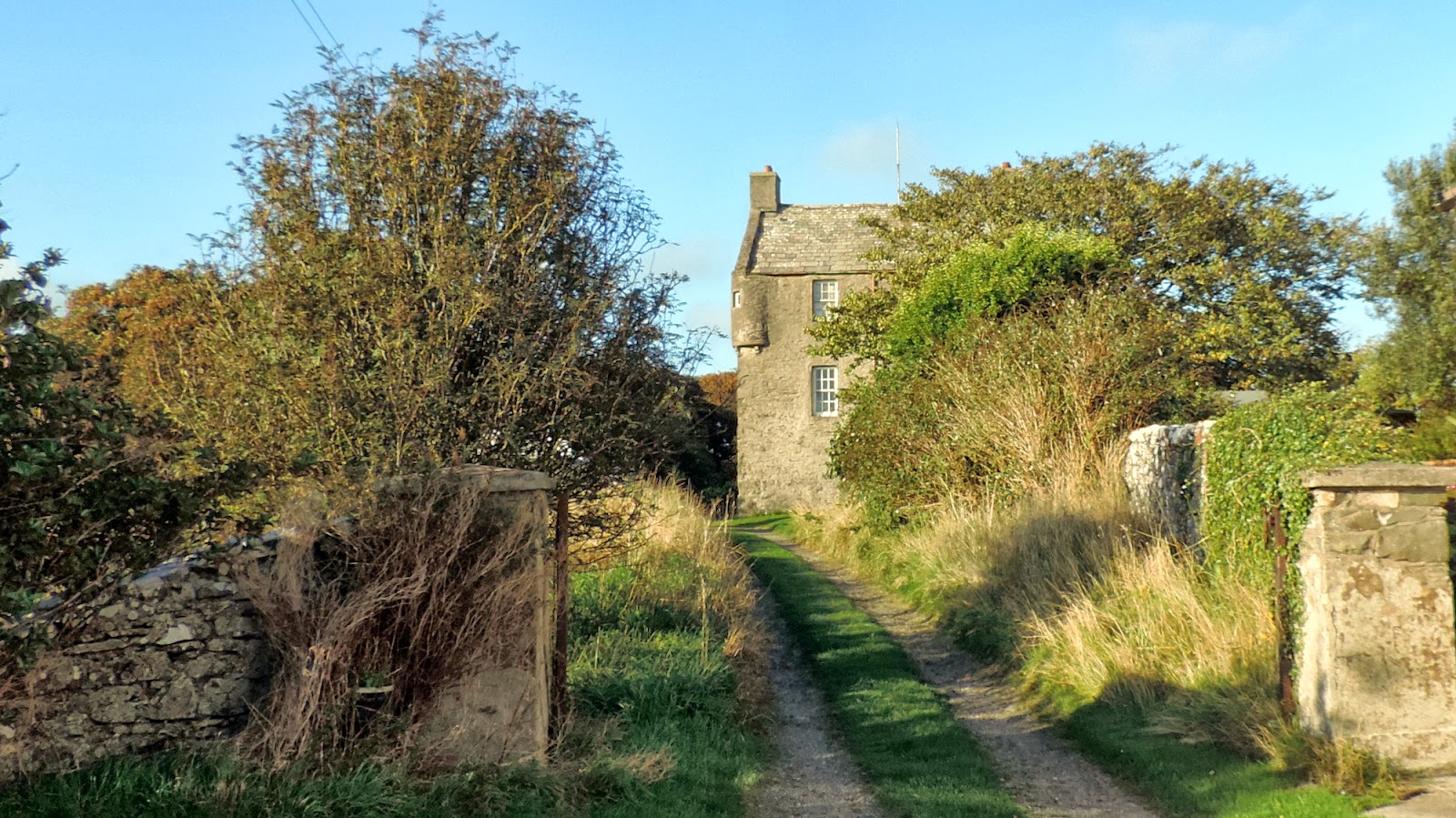
Before moving on to St Medans I got this picture of Physgill House through the trees.
One time belonging to the Stewarts of Earls of Galloway fame.
The present building dates back to the 18th century but according to Canmore it was preceded by an early 17th century tower-like structure.
During the first world war it was utilized by the military and known as
Physgill Auxiliary Hospital. This Twitter link shows a photograph of the Commandant (same as matron at a guess)
.JPG)
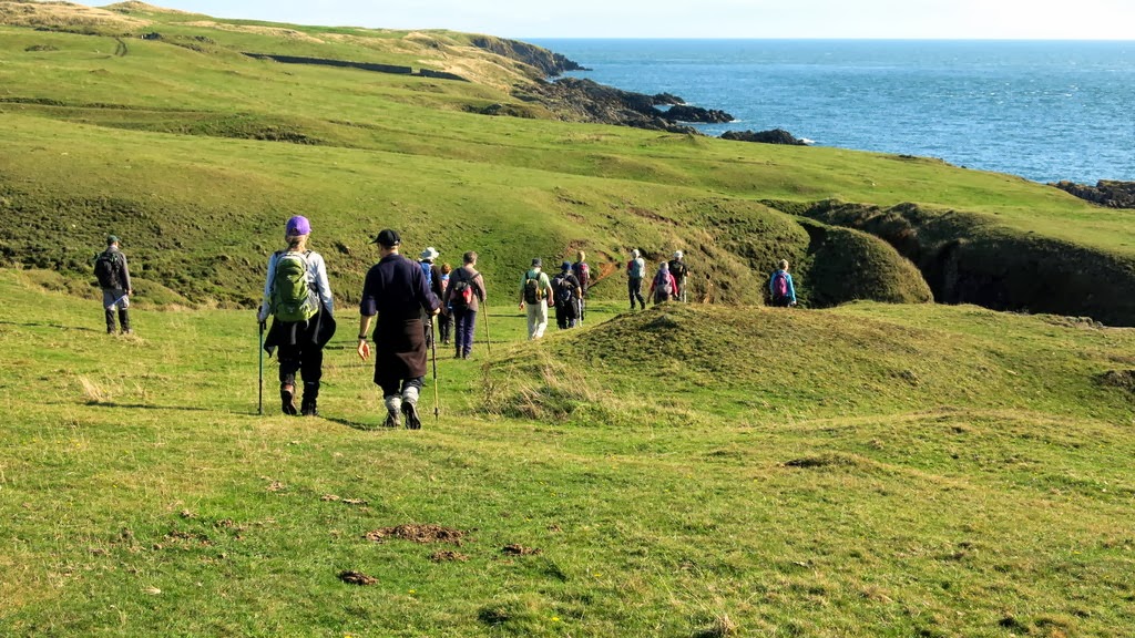
The initial climb.
.jpg)
Spring colour blooming
.JPG)
Cairndoon
.JPG)
A still and animated study
.JPG)
Fishing boat with half a sail
.JPG)
Incline to Knockgulsha
.jpg)
Shags and a raven
.JPG)
A decayed leaf showing it's skeleton
.jpg)
Burn below Carleton Fell
.jpg)
Stile and 'Lunky Hole' on drystane dyke at Laggan Loch.
More in Scoop's pictures.
.JPG)
Climbers and rounders
.JPG)
Laggan camp promontory visitors
.JPG)
Climb to Glasserton Fells
.jpg)
Cup and ring marks
Dull recce pictures left, sunlight picture and HDR (High Dynamic Range) right.
.JPG)
Three tier lunch
.jpg)
The rock of ages
.JPG)
Zoomed in as the distance walkers pass the road to Claymoddie.
.JPG)
Port Counan..............
.jpg)
..............not as deserted as it looks !
.JPG)
A last look at the long walk ramblers as they ascend from Port Castle
.JPG)
A precarious descent for the short walk group
.JPG)
Entrance to Physgill Glen and walk end for the six mile group.
Here's a selection of fine pictures from my fellow snapper
SCOOP
.JPG)
.JPG)
.JPG)
.JPG)
.JPG)
.JPG)
.JPG)
.JPG)
.JPG)
.JPG)
.JPG)
.JPG)
.JPG)
.JPG)
.JPG)
.JPG)
.JPG)
.JPG)
.JPG)
.jpg)
.JPG)
.JPG)
.JPG)
A grand day in the sunshine for both sets of walkers
Here are the reports
Saturday 21st of March 2015
Wigtownshire Ramblers
A fine sunny morning saw 30 walkers assemble at St Medan's beach car park for the walk.
We would stay as one group until lunchtime when we'd split into two groups.
Eleven walkers would finish their walk at St Ninians Cave car park while the remainder of the group would continue on to the Isle of Whithorn.
After walking along the beach we arrived at the cliff edges adjacent to the 4th green and 5th tee.
Here we made the steep precipitous climb to the cliff-tops, probably the most difficult section of the whole walk.
Now we headed south on the cliff path. We looked over Callie's Port and the Red Gate caves. The sunshine highlighted the varied and irregular rock formations.
A hole in a smooth slab of rock was pointed out by the leader as being Neptune's Throne or Neptune's seat.
Out in the bay a fishing boat made a picturesque scene. The Isle of Man was prominent throughout the walk.
We rounded the bay where the Grey Mare's Tail waterfall tumbles over. Seagulls were in abundance while shags sunbathed on rocky outcrops.
Wild spring flowers particularly celandine were emerging everywhere.
After passing the Lochans of Cairndoon we took to the inland fields to reach Knockgulsha, a derelict building on a high point overlooking Carleton Port.
This rarely visited stretch of coast has more than it's share of washed ashore flotsam and jetsam, including a great variety of coloured fish boxes.
Next we reached a wee picturesque glen through which runs the burn flowing down from Carleton Farm. Once across the burn we began a steady climb up the lower slopes of Carleton Fell.
On reaching Laggan loch, most of us crossed over a stile on the drystone wall. However, some of our more lithe and supple members managed to crawl through the 'Lunky Hole' which in turn saw more cameras being produced. A short sweetie break was taken here.
Back on the move, and with the Fell of Carleton looming above, the large pear shaped promontory fort of Laggan Camp was climbed by most walkers while a few of the less energetic encircled it.
Next we walked up a long incline to reach the rocky fells north of Glasserton Hills. On arriving we disturbed five or six deer, last seen with their distinctive white bushy tails bounding over the gorse bushes. Here a large rock looking like the hull of an upturned boat was found and inspected. Earlier in the week on a dull day, cup and ring marks were difficult to identify. On this day of bright sunshine, around a dozen were visible in all their glory. This was our lunch spot.
After lunch the group split into their respective groups with the long distance walkers leaving first.
The rest of us now continued at a less severe pace across to the lower slopes of Glasserton hill.
The odd pheasant, snipe and corn bunting were disturbed along the way.
We were soon above Port Counan where we could see the other group making good headway on the fields below Claymoddie.
In the fields below, a farmer and children were enjoying looking at a new born calf while a family camped nearby enjoyed walking along the beach.
After another sweetie break we continued along the shore path until we were overlooking Port Castle. We could again see the Isle of Whithorn group snaking up the hill to Lobbocks, they were making very good headway.
We on the shorter walk now made our way climbing through the woods to gain access to the path up Physgill Glen.
Snowdrops and daffodils brightened the walk to the car park.
Now drivers were ferried back to St Medans to collect their vehicles while others made their way to the Isle of Whithorn.
Once reassembled, we enjoyed after walk refreshments in the new village hall cafe.
Meanwhile the longer walk group were making good headway, but were always going to be too late for tea and scones.
We reunited to ferry them back to St Medans or to the pub.
St Medan’s to the Isle of Whithorn.
Part 2
After lunch the group split with just over half continuing along the coast to the Isle and the rest heading up Physgyll Glen to the St Ninian’s Car Park. The cliff walkers went ahead and were soon out of sight of the other group. After descending through the wood to the main track to St Ninian’s cave we turned down to the sea shore where several visitors were making their way across the shingle to the cave. One pair was scrambling about on the precipitous rocks above the cave.
Glancing briefly at the site of the walled enclosure of Port Castle, now inaccessible among the tangle of the low growing thorn bushes, we crossed the beach and commenced the climb up to the cliff top. We soon reached the gate at the cliff top with its way mark sign held in place by old fishing net and the somewhat battered plastic skeleton. The path now largely followed the cliff edge with dramatic views over the crumpled rock strata and the sparkling blue sea. The Isle of Man stood darkly in the haze on the horizon, close enough for our mobile phones thinking we had crossed the water and wished to charge us the excessive roaming rates.
A little further on evidence of 18th century activity came in the shape of the Tonderghie Copper mine workings, sometimes known as the Mary Mine. The walk leader had provided a map from a 2003 survey which identified various mine workings. We remarked on the deep open shaft at the base of the cliffs and the filled shaft and water lade on the bank above it. A deep crevice in the rocks gave a view down to the sea. It was not clear if this was a natural feature or part of the mine.
Next we reached the Burrowhead Caravan Park, built on the site of the WW2 RAF Anti-Aircraft Training camp. The walk leader also pointed out the promontory fort and ruins of Castle Feather and two wooden stumps embedded in concrete which were all that remained of the structure burned in the final scene of the Wickerman where Howie alias Edward Woodward met his fate.
After a pause for sweeties we carried on around Burrow Head and reached an isolated WW2 pillbox. Here we were delighted to watch a pair of seals playing in the gentle surf around the rocky promontory. We also spotted what appeared to be large jelly fish wallowing in the clear water. Closer inspection revealed these to be roughly circular patches of foam which undulated in the tide. A most unusual effect.
Soon the Isle of Whithorn and the distinctive square white lookout tower came into view. The tower has been a mariner's landmark for close on two centuries. As the group descended into the village the declining sun shone on the harbour providing a picturesque finish to a long hike. Here we met the remainder of the group who were leaving the café. Some went back to fetch cars or go home. Hardier souls wandered through the village to enjoy a long anticipated pint in the sunshine outside the Steam Packet Inn.
Next Saturday's walk on the 28th of March will be the re-scheduled climb up Curleywee and White Hill. This was originally on the programme for January the 31st but had to be postponed due to bad weather.
Meet for car sharing at the Breastworks, Stranraer 8.30 am, the Riverside, Newton Stewart 9.00 am or the walk start at the White Laggan Bothy on the Southern Upland Way road (NX 468 778) at 10am.
For more information or if going direct to the walk start contact the walk leader on 01776 700926.