Clicking a picture will bring up all the posts pictures in a slideshow. To view an individual picture in full screen, right click and select 'Open link in new tab'
Showing posts with label Waterside. Show all posts

Sunday, 30 March 2014

Wigtownshire Ramblers The Lost Villages of Ayrshire March 2014

Saturday the 29th of March
We're heading north to Waterside for today's walk.
Previous posts for this area can be found at
and

I'm today's leader and the report will follow the pictures. There'll also be a few pictures from Monday's recce with the 'Ranger'. 
Thanks to both Scoop and the Ayrshire Blogger for their contribution of photographs.

The leader.
Thanks to the aforementioned blogger for this first picture.


The Drumgrange Burn and Patna.


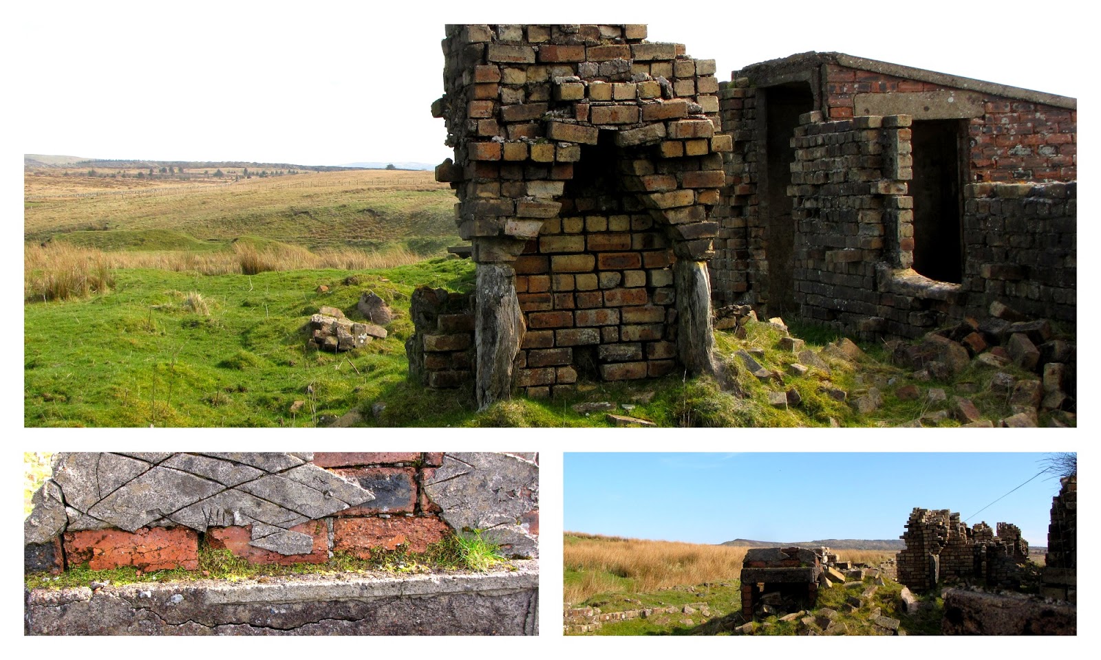
The Drumgrange Incline.


This one from Scoop.


A collage from the recce.
It was cooler but brighter.


Just about to enter the village of Lethanhill.


This is looking along the Auld Schuil (school) Row.


White Brick Row and Briggate


An interesting photographic portrait from Scoop.


More from Scoop.


A wonderful piece of civil engineering.


It probably would have withstood our crossing, but it wasn't attempted.
My call of "Yer on yer own", became the catch phrase for the group's wags for the rest of the walk.
The 'Weaver's' warning however carried more threat and weight.


The crossing to the  war memorial at Benwhat on Benquhat Hill.


It's still well looked after and frequently visited.


A group photo from Scoop.


Pictures from the recce showing snow on the Galloway Hills. During the recce there was barely a moment when we didn't see an aircraft above us.


Lunch at Benwhat.


Crossing to Burnhead.


Lots of slagheaps and bings.


Burnhead and Corbie Craigs by Scoop.


She also waited for this beauty.......


................and this.


Corbie Craigs Village.


More from Scoop.


Alongside the Rough Burn.


A well built tunnel. The flower, thought to be a Colt's Foot, was growing completely submerged. 


Abandoned vehicles and stone carvings.


A group photograph from Gordon.
Cheers !

Another cracking collage of Scoop's pictures..........


..............and more from the recce.


Pipe across to a disused mine shaft.


More recce pictures. The two Hercules were so quiet that I only just got a picture of the one at the back. I wouldn't have got that but for the 'Ranger' being alert.
There's a photographic video by Abandoned Scotland of Dunaskin on 
The site is also up for sale at a giveaway price.
There must be a billionaire out there, possibly with Scottish roots, willing to fork out and save this site for Scotland's heritage ?


These last ones are from Scoop. Looks like she fancies herself as an engine driver.


Thanks to Google for this last picture.
It's the Eglington Hotel in Dalmellington. Thanks for a delicious and sumptuous spread Tom.

Here's the report.
Wigtownshire Ramblers 29th March 2014  

Twenty one walkers gathered at the entrance to Dunaskin Ironworks for the walk. The weather forecast was for a good day.
Starting out in a north westerly direction, our first point of interest was the grade two listed building that is the Waterside Institute. Here we saw the first of three war memorial that we’d encounter today.
Now we climbed a few steps up to the disused rail line leading to open countryside. Here the open fields were dotted with odd brick buildings once associated with the mines and ironworks. At the Drumgrange burn a line branched uphill. This was the track of an incline drum and steel rope haulage system for raising and lowering rail bogies. A steady climb led us to the ruins of the drum housing. Open cast coal quarries lay abandoned to the west.
Here we saw and heard the first of the many skylarks that nest on these moors.
Now a level track took us past the second war memorial where those remembered were mostly conscripts of the Royal Scots Fusiliers. It was hard to believe that this was once a busy street separating the villages of Burnfoothill and Lethanhill. Further on, a large white painted stone declared 'Long Live the Hill'.
At the ruins of what was once the village store we entered the wood that encompasses the former village of Lethanhill. Here, thanks to an old map we walked along Whaup Row, White Brick Row and Briggate. The terraced houses now mostly reduced to rubble gave a fascinating insight to an age gone by.
Leaving Lethanhill we now headed east along a track. Only used by shepherds, walkers and wild animals these days, this track once carried bogies filled with coal and iron ore.
The track now took us to the edge of the former hill village of Benquhat.
From here we walked across a somewhat swampy moor to climb to our third war memorial, this one also remembered conscripts of the Royal Scots Fusiliers. Wreath laying ceremonies still take place annually. A short break was taken to enjoy the somewhat misty views.
We now retraced our steps to Benquhat where we walked among the ruins of the school. Broken porcelain identified the toilet block.
Slag heaps and ironwork mounds are scattered across this area and it was between these we found a sheltered spot for lunch.
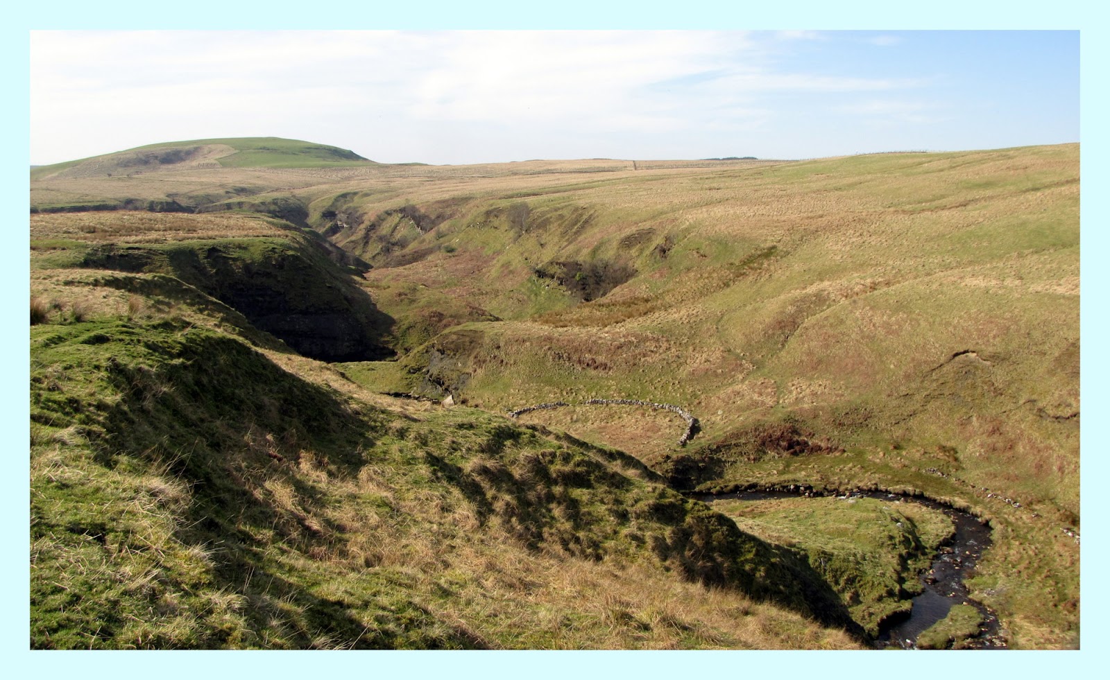
After lunch we made our way across more moor and old workings to the head of Corbie Craigs. With the sun now breaking through misty skies, we took our time to view the tumbling waterfalls in the deep gorge below.
A little lower down we came to Corbie Craigs Village. This was a single row of terraced houses built by the Dalmellington Iron Company in the 1850's. The village was abandoned in the 1950's and left to ruin.  A local man we encountered remembered visiting his grandfather here back in the nineteen forties.
Now we followed the Rough burn uphill to cross an old bridge where several initials were carved into the stonework. Once on the opposite bank, we followed the burn to where it converges with the Burnhead Burn to become the Dunaskin. Here we followed the undulating track overlooking the beautiful Dunaskin Glen. A disused rail track ran alongside.
At a high point where the burn turns sharply south we came to the site of Laight Castle, belonging to Alpin, King of the Scots. He was defeated and killed in battle in the 9th century; there are conflicting reports of where and when he died. He is our present queen's 34th Great Grandfather. Nothing remains of the castle, but we could imagine the drawbridge. We took another short break here to enjoy the ambience of the area. A peregrine falcon was spotted across the gorge.
Back on the move and with the giant chimneys of the Ironworks in view, we were soon walking into the grounds of the Dunaskin heritage centre.
Boarded up and abandoned were turbine houses, ovens, kilns, and a wonderful 1847 Italianate blowing-engine house. redundant relics of an industrial age that once was the lifeblood of South Ayrshire. There's still life here though, volunteers from the Ayrshire Railway Preservation Group are always around preparing for the Steam Open Days in the summer.
Back at the cars, we now made our way into Dalmellington and the Eglington Hotel where we enjoyed scones, cakes, tea and coffee, an indulgence likely to counteract the good healthy work of the walk !

Next week walk; the 5th of April will be an 8 mile circular from Stranraer to Castle Kennedy. Meet at the Riverside in Newton Stewart for car sharing at 9.15am or the walk start at 10am. The walk starts at the 10am in the Breastworks car park in Stranraer (NX 059 610). New walkers are welcome but please speak to the leader first on 01776 840226.

Friday, 23 March 2012

Dunaskin March 2012

Thursday the 22nd of March.
I'm just a few miles north of Dalmellington to walk with a fellow rambler at a place that intrigues me.
The village is Waterside, but what was an Ayrshire industrial heartland is 
Dunaskin
This from Future Museum
The hills around the Doon Valley in East Ayrshire held a wealth of coal, ironstone and limestone. The Dalmellington Iron Company employed these to produce pig iron at its works at Dunaskin. Its furnaces operated 24 hour a day from 1848 until 1921 and employed 1400 people. Forced to shut the furnaces due to a slump in demand, the Company survived for a few years on its coal business alone, before, in 1931, taking advantage of the demand for bricks and redeveloping the blast engine house as a modern brickworks.

We parked up close to the big chimneys


This lovely building may have once been the miners institute


We set off in a North Westerly direction. A gradual rise brought us to the dismantled railway track to Lethanhill 
I'd initially planned to take the track to Lethanhill, as in this AA walk,  but had a change of heart and decided we'd climb Green Hill and make our way to Dunaskin Glen from there


Green Hill was a fairly easy climb, but boggy in places.
The sound of Skylarks filled the air


From Green Hill the views are across to Patna, back down to Waterside, a sheepdog rounding up sheep and all that remains of the railway incline head at Lethanhill. The incline was also known as the Drumgrange incline.


To the south is Bogton Loch and the River Doon
(Green Hill is ok for a climb once. Next time we will take the track to Lethanhill because that is where the history is. Ayrshire History - Lethanhill )


The whole area is testament to the industrial past, with slag heaps and coal seams just about everywhere.
Just below Benquhat Hill is a lonely war memorial.


We find the track which comes over from Lethanhill which brings us to Corbie Craigs and the Burnhead Burn, a tributary of the Dunaskin Burn


Here, the ravines and waterfalls are spectacular, and my photographs don't do them justice . 


After passing the ruins of Burnside Farm we make our way down to this row of ten cottages. We stop for lunch overlooking Rough Burn.
 Corbie Craigs Village was built by the Dalmellington Iron Company in the 1850's to house workers at the nearby mines which served the ironworks at Waterside. The village was abandoned in the 1950's and left to ruin. 


Amazingly some chimney breasts are still standing. Above left the initials of the plasterer can be seen


The bird that got the worm. My walking partner tells me this is a Blackcap.
As well as the Skylarks, we also saw Ravens and a Peregrine Falcon


A well baked cowpat, strategically placed wrecked cars, and another view of the hillside war memorial


A footbridge over Rough Burn takes us across to the south side of Dunaskin Glen


Overhead this plane's just taken off from Prestwick


More industrial remnants


Corbie Craigs Miners row from across the glen


Now we follow an undulating ridge high above Dunaskin Glen.
It's a brilliant scene. The romans were here, and in Scottish history the 68th King of the Scots met his fate here
King Alpin Slain in the Glen of Dunaskin
Another interesting point is that our present queen's lineage see's Alpin as her 34th Great Grandfather 


The point at which the Burnhead Burn and the Rough Burn become the Dunaskin Burn


Looking down Dunaskin Glen to Green Hill


Coal seams are still visible in places


This is what's left of Laight Castle, King Alpin's stronghold. 
Alpín MacEchdach ascended the throne in 834, he probably had a Norse wife and reigned for three years until being slain here in 837 


Re-enacting the scene a long time ago, Queen Brunhilde on the castle steps scours the land for any sign of her gallant king.


Dunaskin Aquaduct


Three sides of the approach to Laight castle.
It's a grade C(S) listed building


The burn takes a sharp turn at Laight and meanders back towards Waterside


A pair of these flew over. Is it a Mustang ?


This is our last climbing obstacle. Most of the gates today seem to have had either permanent locks on them or have been well wired up.


The Scottish Industrial Railway Centre has been neglected for some time.
The Ayrshire Railway Preservation Group are busy breathing new life into the project and have a arranged a number of open days in 2012, with a new cafe area being developed


More remnants of Dunaskin's industrial heritage


I wonder which Fife pit No 23 served. Maybe an uncle of mine once drove it.


These are the brick making kilns of


Inside one of the kilns


We got talking to the owner of this Westie, he'd just been looking for a wee lizard of some sort.
He talked of the decline of this part of Ayrshire, and how all industry had closed and never been replaced with anything else. No wonder unemployment is high, the area has never recovered from pit and factory closures

This is a Grade A listed building of the Ironworks built in 1847
This was the end of our walk.
What a great day.

Thursday the 29th of March

We're back at the Dunaskin Works.
My plan was to walk up to Lethenhill and Burnfoothill to explore these lost villages of Ayrshire.
It didn't go to plan since the O.S map don't update with great big open cast mines.
We got to what was left at Lethanhill, but then had to head south, and retrace much of last weeks route.
Here's a few extra pictures.
Setting out north west we came across this lovely memorial plaque. 
The track up to Lethanhill is a disused rail track.


There's plenty of remnants of the railroad. The loch (bottom right) has been created by the opencast workings.


 The war memorial to the Lethanhill war dead is well kept and protected with a decorative wrought iron fence around it. It's a good job, cause here's what's in the field...............................................


.............................................................highland cattle. I got in the field to take the pictures of the memorial, and these highlanders remained quite placid.


 A nostalgic reminder


 I had the feeling there would have been more ruins like those at Corbie Craigs, but if i'd read the following passages more closely I'd have seen that most of them had been demolished.

The Doon Valley Hill Villages

Benwhat (the locally preferred spelling, rather than the Ordnance Survey's 
Benquhat) and its sister villages of the Doon Valley in Ayrshire no longer 
exist. It was one of several villages created in the Doon Valley of 
Ayrshire by the Dalmellington Iron Company in the 19th century. The hill 
villagers came to the area, in common with families from Ireland, England 
and elsewhere in Scotland for work in the rapidly expanding iron workings 
and the iron and coal mining which supported it. Most of the incomers lived 
in these new villages. They either moved on to housing in the more 
established areas of Waterside, Patna or Dalmellington, or in the majority 
of cases remained in the new villages. The communities so formed were close 
knit, independent and very hardy in the difficult circumstances of hill 
life, especially in the several periods of decline of the iron industry.

Six villages were created in the period 1840 to 1885; only one of them 
remains in anything like its original form. They were: Waterside, astride 
the River Doon between Dalmellington and Patna; the twin villages of 
Lethanhill and Burnfoothill on the Knockkippen plateau at 900 feet above 
sea level and 1¼ miles above Patna and the River Doon; Benwhat, and its 
close neighbour Corbie Craigs, were smaller villages higher up the plateau 
above Waterside; and lastly Craigmark in the hills closer to the town of 
Dalmellington.

Waterside, of some 89 houses in 1851, grew around the original iron works 
which were built between 1846 and 1856. The works are now sadly derelict 
but the target of a local conservation group who are beginning a heritage 
museum to illustrate the life of the 19th century miners and iron workers. 
The village lies astride the River Doon between Dalmellington and the 
largely 20th century mining village of Patna.

The twin villages of Lethanhill and Burnfoothill were built between 1849 
and the 1860s on the Knockkippen plateau at 900 feet above sea level and 1¼ 
miles above Patna and the River Doon. The villages were a series of miners 
row houses built by the Dalmellington Iron Company close to the iron pits 
and open hearths where the men worked. The Iron Company also controlled the 
village store and the inclined railway which carried coal, iron ore and 
part refined iron char as well as working miners.

Benwhat, and its close neighbour Corbie Craigs, were smaller villages 
higher up the plateau above Waterside. Corbie Craigs was probably the 
original hill village of only 10 houses built in the early 1850s to support 
the ironstone pits at Corbie Craigs. Although Corbie Craigs may have 
originally been attended to be the centre of a large hillside mining 
community, its growth was stopped by the shift of interest to Lethanhill 
and Benwhat. The need to develop mines higher up the plateau allowed the 
Iron Company to build Benwhat, built between the early 1860s and 1875, and 
totalling 130 houses.

Craigmark which was built in the latter part of the 19th century and 
comprised 6 rows - a total of some 80 houses - to support the Minnevey and 
Sillyhole coal mines, lay closer to the town of Dalmellington.

The houses and life styles in each of these villages appears to have been 
very similar. The villages included a store, and eventually schools and 
churches and were very self contained with their own community 
associations, sports teams and social gatherings. They were dependent on 
the villages in the valley only for supplies, medical support, cemeteries 
and of course work!

The hill villages were run down in the 1930s and then finally evacuated in 
the post war period with the families being rehoused in new estates in 
Patna and Dalmellington. The buildings were demolished and little remains 
to show 100 years of life on the plateau, save the memorials erected close 
the churches and the foundations of the rows - some close to the 
foundations of 17th century farms which were victims of earlier clearance 
policies! The moors are now inhabited only by wild life, the ghosts of the 
past and occasional visitors.

The village families were remarkable in their determination to improve the 
lot of their children and to provide the best education possible. As a 
result the descendants of those original Benwhat and Burnfoothill families 
have made their mark in several parts of Scotland in education and 
government, in New Zealand, the USA and in Canada.

After Lethanhill, the O.S map gives a track heading west, then circling back east to Burnfoothill, but all we could see was opencast workings with 'Danger' signs around. So, plan B (there wasn't one until now) was put into operation which saw us again make our way over to Corbie Craigs and down Dunaskin Glen. We lunched overlooking the confluence of the Dunaskin and Rough burns.


At Laight Castle I decided I wanted to get down on the promontory (top left).
Once down I took a ten second self timer, and though it doesn't look it on the photo there's quite a drop behind me.  Queen Brunhilde's waiting to see if King Alpin makes it back up to finish the walk.

  
 New buds and old tassles.


We walked by the railway stock to finish today's walk
 
There's some well rusting pieces here, a few reminding me of times long ago in my working life.
Another enjoyable, if a little disappointing (no villages), walk with my rambling friend from Ayrshire 
Related Posts Plugin for WordPress, Blogger...

Photographs

Creative Commons License
This work is licenced under a Creative Commons Licence.

Morning deer

Morning deer
is someone watching me