Where's the snow I asked on my last post.Well it arrived overnight.
Nothing like the quantity they've been having over on the east coast,but enough to notice.
I resurrected my Fuji to take pictures today,but I omitted to change the settings and ended up taking pictures on the default setting of lowest quality.Hence no absolutely brilliant pictures.
I'm writing the press report for todays walk.Once again that will be the text of the post.Although the walk is a new route,we've covered most sections of it at some time or another.
Walk Report 27th of November 2010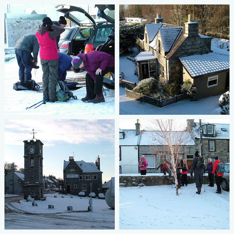
An overnight fall of snow covered the ground as the ramblers gathered at Adamson Square Creetown for the walk.Fourteen set off but soon became fifteen as one latecomer caught up with the group.

They began by heading north out the town, then taking the old military road to the north east.
Remnants of the old railway line and the modernised stationmasters house were pointed out by the walk leader.

They continued across the Kilwhirn Bridge past Barhassie and on to Greenburn,where a variety of exotic plants lined the road.


Once across the Greenburn bridge they turned southeast and crossed snow covered fields to emerge on the road leading to the Cairnsmore of Fleet National Nature Reserve.

A short walk took them over the Chain bridge and into Chain Wood to follow the path above the well flowing Moneypool burn.

Once out of the woods,a gentle incline,curious cattle and two drystone walls took them to the tarmac road at Craigenboy.

Another change of direction took them south onto the Glenquicken road through a kissing gate and into the 'Oak Trail' of Balloch woods.
 Courtesy of Scoop,I get in the picture
After following the delightful and well laid out path for a kilometre they crossed the Darach Bridge and emerged at the Garrochar wildlife ponds.

Here they took a short break to look at the roundhouse interpretation centre and the frozen ponds with curious patterns in the ice.

They also learned from the walk leader that this was once where the Creetown Curling club held their bonspiels.It was last used in 1945.

Next,a short walk past the Garrocher christmas tree farm took them to the track leading up to Knockeans hill.

A climb of varying steepness saw the group reach the 974 feet summit where a lunch break was taken.Views of the Galloway hills were enjoyed and identified.

Following lunch they followed the path west to the summit of the slightly lower Larg hill.

Here they enjoyed views stretching from the South Ayrshire hills and Ailsa Craig down to a very prominent Isle of Man.The windfarms noted on the groups previous walk were also visible from this peak.
 The Minnigaff range of the Galloway Hills
 A view up the Cree Estuary

Descending south by Raven's Crag they joined the path leading to the Silver hill and Fell hill quarries at Kirkmabreck.Here they visited each of the quarries in turn.The walk leader gave detailed information of their history and how the docks at Greenock, Leith, Liverpool, Birkenhead, Newport and Swansea were built with stone from Kirkmabreck.
 A stitched picture of Fell Hill quarry
Next they descended to the lower Kirkmabreck quarry,once the home of Creetown's late Japanese sculptor Hideo Foruta.After viewing it from above they made their way down to where the light railway system took the quarried material down to the quay,which is soon to be resurrected for timber operations.
 Kirkmabreck Quarry Quay
 The site of the old rail system down to the quay.Now a ski run by the looks of it!
Now parallel to the busy A75 they made their way through the sometimes slippery Castle Cary woods before finding a well established path heading north.

They continued past the holiday park before reaching the Lairds Inn and the ruins of Castle Cary.

Here they saw how part of the castle had been restored to become part of the Lairds Inn.

A little further on they crossed Beardies bridge to re-enter Creetown and the end of the walk.
Although a cold day,all day sunshine made this an interesting and informative walk.

 Custom Search
 I guess these guys were heading for one of the windfarms.
 A frozen inlet gets my plug.
 It's quite a meandering river along this stretch.It also varies in width and depth.
 Very reflective in the deep.
 The ice makes a variety of patterns.
  Strange !
 A muddy frozen inlet where the cattle have walked has produced these frozen structures.
  The Cree will freeze over in places.I think I've posted frozen pictures before.

 Here's a bit of life.The picture I didn't get was the big pike nearly lifting itself clean out of the water.
 The Cree is never boring.
 I finished my wee walk at the Challoch stepping stones.I bet it's a while since anyone crossed here.


