
 Custom Search
Saturday the 29th of September.
Lofty is today's leader.
This is a walk we did two years ago.
Once I get Lofty's report I'll publish it below.

Thirteen of us today. We start on the Three Lochs road north of Kirkcowan.
Another account of this walk will appear on my good friend Gordon from Ayr's Blog

This place is very interesting.
It's an old farmstead that goes by the name of Drumbuie and looks like there's a lot of history about it.
There's a stone in the wall marked 1734.
There's a genealogy page which says a Moravia Charteris was born here, a possible descendant of Malachy King of Ireland.
And there's also a tree (I think that's a picture of it on my last post of this walk) called 'The Boy Tree', where a young 11 year old Peter Douglas was murdered by a tinkler or tinker called Alexander Cochrane.
Details are found in Andrew McCormick's 'The Tinkler Gypsies' (pages 134 to 139) or have a quick look HERE

These dead trees are at the back of Drumbuie

Our next point of interest is in the grounds of Shennanton.
Several theories were put forward to what the enclosure above was used for.


Views over to the Galloway Hills from the River Bladnoch.
The flock of Texel's all had what looked like mud spots on them.

Here's a rare looking work of natures art

Sheep, precarious crossings and the Black Burn.
Looking for anything on the Black Burn, I came across a government document about the proposed Glenchamber Windfarm near Glenluce. Now I've never been anti windfarm, but I'm sure we have enough in this area now. This proposal was rejected by the local authorities, but somehow the Scottish Government believe they have the right to disregard the wishes of the local people.
Here's the link to that document should anyone wish to read it.
Directorate for Planning and Environmental Appeals

Lunch overlooking Barfad Loch

Another look at the enclosed memorial on the loch side. The wreath, bottom right looks well weathered now.It may be in memory of a McKie who were resident at Barfad.

Barfad

Mud. The hill we go past is called Killymuck.........quite appropriate !

A carpet supplied by the Stationmaster gets us over the barbed wire.
Here we head into the Shennoch Plantation.
Shennoch:- from the Gaelic Sean, old and cognate with the Latin Sen-ex
Shennoch:- from the Gaelic Sean, old and cognate with the Latin Sen-ex

The final climb to Culvennan Fell.
Culvennan Fell. Vent breccia. Breccia with generally angular clasts adjacent to the margin of a diorite intrusion. Finely laminated fine sandstone clasts are typical of the host sediments. Coarser-grained white sandstone clasts, sometimes rounded, are exotic.
Don't ask me, I know nothing about geology.!
Don't ask me, I know nothing about geology.!

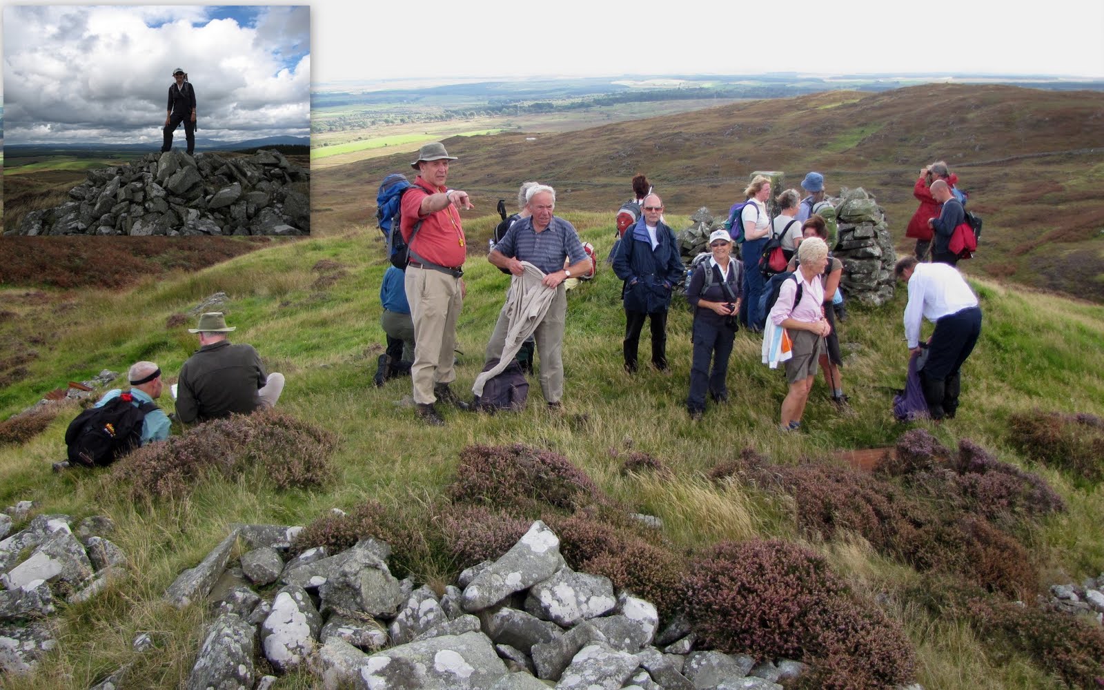
One triangulation pillar and one flush bracket

The group picture.

The trig point is 213 mtrs, the cairn is 215 mtrs.
The Ayrshire Blogger is less than 2 mtrs

Over the fells

I think this may be Chanterelle, apparently edible and delicious.

A wide ranging view east.

We have a feeling that this is a prehistoric site (not the sheepfold), but there's nothing on the O.S map.

The last leg of a nice nine mile hike.
Shorty's report will appear here later.
Wigtownshire
Ramblers – Saturday 29 September 2012
Thirteen
ramblers assembled on the Three Lochs road just north of the A75 on a morning
that promised crisp autumn weather. Dark
clouds to the north suggested something else but the group headed off in good
spirits along the old Military Road.
Some sections were wet and muddy but the solid base created under the
direction of General Caulfield in the 1760s provided a good foothold.
They
soon reached the old farmstead of Drumbuie.
There they paused to inspect the unusual archway which served the
courtyard of the old house. A stone gave
the date of 1734 which predates the Military road. The group continued eastwards along the road
which soon reached a tarmac section which took them to Doonhill Wood. From there they squelched through a gateway
and followed the edge of the wood over a low hill below the main power
line. From there they took to the
attractive woods around Shennanton House.
In the woods they found an unusual dyked enclosure about 4 metres square
with the sides sloping down to the south.
There was no entrance into the enclosure nor any obvious structure
inside. There was much speculation as to
its purpose.
The
ramblers skirted the main gardens and emerged onto the road at Shennanton Sawmill. They followed the road past the home farm and
as far as the Bladnoch bridge. There
they took to the fields and followed the course of the river northwards. As they went along a couple of shots were
heard and, fearful of disturbing a shoot, they proceeded carefully until it
became clear that the noises were only a pair of gun dogs under training. Burn crossings added to the entertainment and
they soon reached the road again. After
crossing the road they entered another wood and soon reached their lunch stop
overlooking Barfad Loch.
Lunch
was curtailed by a sudden sharp shower so the ramblers donned their wet weather
gear and headed for the old track which crossed north of the fells. The rain soon stopped but the track got
wetter and the presence of cattle made the going a little difficult. The route crossed a fence into the forest and
the going got easier. There was a short
pause at the ruins of Shennock farm where the walk leader recounted a tale of
an army exercise where the unsuspecting shooting tenant was confronted by a
troop of armed soldiers supported by small Scorpion tanks. He felt somewhat out-gunned.
After
leaving Shennock the ramblers followed the little used forest road to the top
of Shennock Fell. The main users seemed
to be red and roe deer which had left many tracks in the muddy sections. The group then cut through the trees and
emerged onto the open moorland. A short
climb led them to the cairn and trig point on the top of Culvennan Fell. There were excellent views in all directions
with odd features picked out by patches of sunshine as the clouds scudded over
the sky. A pair of diggers were working
away on the summit of an adjacent hill but it was not clear what they were up
to.
The
group descended the southern side of the fell and then a short rise led them to
the summit of Crunlae Fell. After
admiring the views over the Machars and Wigtown Bay they continued on down
following a well-used sheep track. On
reaching the lower ground they found evidence of several ancient structures. One had the appearance of a chambered cairn
and another seemed to be the outline of a building but there was nothing marked
on the current maps.
The
route then followed a rough path over green fields and bracken knolls with
boggy sections and deep burns between them, after which they re-joined the
Three Lochs road and regained the cars.
It had been an enjoyable but testing walk of 9 miles.
The
next event, on Saturday 6th October, is the popular walk around
Newton Stewart. Meet at the Breastworks
Car Park in Stranraer at 09:30 to share transport. The walk will start from the Riverside Car
Park in Newton Stewart at 10:00. (Grid Ref: NX 412 653) New walkers are always welcome. For any queries, please contact the walk
leader on 01671 403351.


