Clicking a picture will bring up all the posts pictures in a slideshow. To view an individual picture in full screen, right click and select 'Open link in new tab'
Showing posts with label Holm Ferrach. Show all posts

Wednesday, 6 July 2011

Larg Hill Recce

Monday the 4th of July.
The American day of Independence.
This was supposed to be the best day of the week,and as I write this midweek it seems to have been the case.

This is the recce for this coming Saturday's walk.It's one we've done before.
APRIL 2010

The least interesting part of this walk is the long forest road walk in to the climb start.

It's a great day though......

....and there is the memorial cairn and ruins of the village at Holm Ferrach.

We haven't had a lot of rain the last few days,but there's still a fair bit of water coming out of the hills.


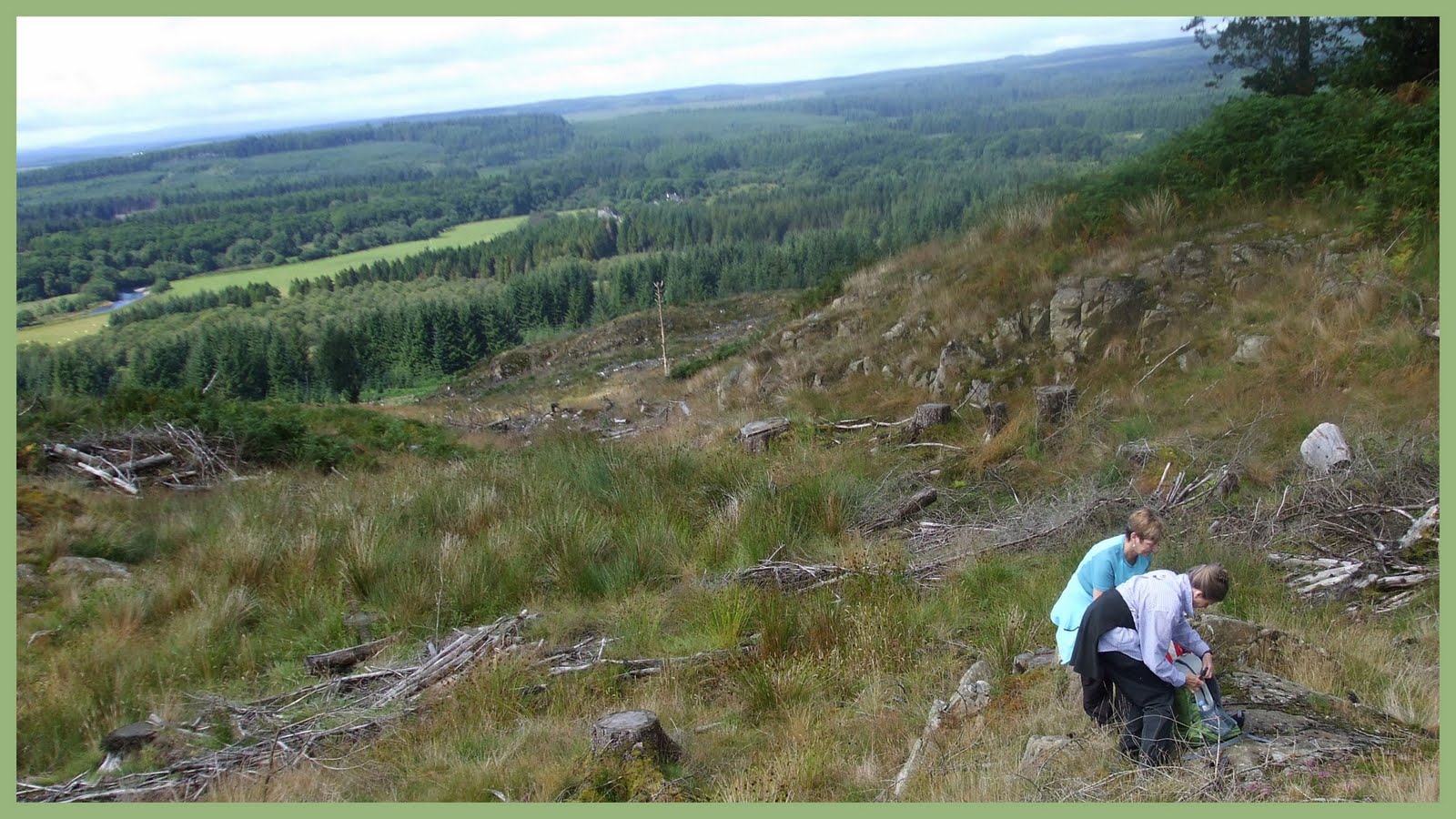
I nearly missed the drystane dyke at Craigenteasy.A fallen branch obscures it a little.
This is where the climbing starts.
Tussocks and boggy ground make the climb start a bit of a haul,but once I'm above Punch Well Brae the going got easier.
Distance views were quite hazy though.I've enhanced quite a few of my pictures to compensate.
In the above picture is the dyke I'm following,Wigtown Bay,Arecleoch Windfarm and Ailsa Craig and below me Loch Middle .


 Once clear of the forest,the Blaeberries (Bilberries) looked ripe.

This one's on it's way to being digested.

This is the lower of Larg's two peaks.
I took ten second delay self portraits on each of my peaks.The results weren't very flattering and as Slewtrain says I've time on my hands.
I'd say at least 80 % of this picture is untouched,don't know about my brain though.Still he's a reasonable lookalike.

These are the views I got between Larg Hill's two summits.Below me is Craignaw.(I believe this gets called little Craignaw so it isn't confused with it's higher namesake above the Silver Flowe National Nature Reserve)

Now this is me again on the higher of the two Larg Hill summits.The ten second delay function seems to be causing the light to play tricks,I think I look pretty cool here.

Here's a closer look at Craignaw as I enjoy my lunch.It's steep and rocky below.

Now I'm on the move again and get this view of Curleywee.I still haven't been up there.


I've had to take a round route over to Craignaw.Below Larg to the north west is what I believe in geology is called a 'Cirque',a bowl like depression left over from the glacial periods.
The top picture in the above collage is Larg Hill from the north west.
Sheep,lochans and bogs get photographed on the way over.

There's no trig points on any of these hills,but there's a really good all round view from here on Craignaw.
I took pictures to make a 360 degree panorama,but I haven't stitched them together because of the haze.It would be a cracker on a clearer day.

Some thing wrong with the ten second timer again,but that's definitely the real me this time.

Now I begin my descent.
Steeply below is the Mulmein Burn,I'll follow that then as it then joins another tributary to become the Caldons Burn.

It's a beautifully scenic flow of water.

As I descend I get good views over to the hills north of Loch Trool.
Top left in the above collage shows Bennan,Benyellery and the Merrick.

The paths aren't too well defined and not well trodden either.It's quite overgrown in places,but I make steady headway.

Now I come to the ravines and steep drops that the pictures wont do justice to.Someone needs to go down to show them in perspective.The path comes perilously close to the edge at times and in the event of rain on Saturday,Larg Hill will have to wait for another day.

Continuing my descent below the ravines,I get to some more accessible waterfalls.The tree trunk in one looks almost petrified,I guess it's been there a while.

This is an amazing water drop after a lot of rain.
I took a picture of it in full flow once but it didn't come out good.

I'm almost down and there's a patch of colour in wild orchids and bell heather.I get my macro working.

The last stretch gets me past where they're quarrying stone.(trees were being felled here the last time),a hollysprig next to a moss covered stone,the campsite at Caldons and a young lady preparing food for some developing youngsters.
Venture Trust looks like a worthwhile organisation.

And finally an untouched reflection of me on the bridge over the Water of Trool.

I'm heading home now,hungry sweaty and nearly out of drinking water.
What's this police van doing at the Glebe.Oh no ! they're evacuating the residents after an explosion on a nearby work site amid fears of more gas cylinders exploding.
The biggest bang ever experienced in the Glebe which shook the houses and occurred around 2pm and I missed it.

Before I head for Penninghame Primary school,the information and evacuation nub of the incident, I've got to get some refreshment from the supermarket.

Suitably refreshed I head for the school where I hear the stories from other residents.
After a while we get the all clear,it seems there's been no injuries and everything's cooled down.

A good day,but I'm glad to get home. 

Sunday, 8 August 2010

Wigtownshire Ramblers Stroan Bridge Circular August 2010

Saturday the 7th of August 2010.
Todays walk will be a circular taking in riverside and forest.
Gathering at the Glentrool Visitors Centre at Stroan Bridge car park we're a group of twelve today.Our guest quadruped is the lovely Bella,
We begin by heading south alongside the tumbling Water of Minnoch.
There's some dampness in the air,but the forecast is good.It must have rained through the night,there's a good flow on the river.
Reaching the Water of Trool we head along to a section called the Black Loup.Here we cross the Trool via a fairly new footbridge.Now we rejoin the path along the Minnoch.

The grass is quite wet underfoot,but not too long to give us any problems.Across the river is an area called 'Auld Wife's Stank'...interesting !

Opposite High Minniwick now we see the ruins of Dalane Cottage.I wonder when it was last occupied ?

Sections of the river are really picturesque.

Continuing on we reach the bridge at Holm where we encounter a pair of birdwatchers.It seems our walk leader Shorty knows them.

A dodgy footbridge is traversed....

....and we reach this scenic waterfall.

Thanks for these pictures Scoop.
The 'Old bridge of Minnoch' commonly and locally called the Roman Bridge.(Possibly from Romany),is thought to be 17th or 18th century.
We have a short break here before a precarious stony scramble takes us onto forest road.

Now we're heading east and north for a long section of forest road.
Bella's in her element now....


....but she finds a stick that's too big to pick up.Look at that tail go !

Here's another excellent outlook from my fellow snapper Scoop.

Now we reach Holm Ferrach.I've blogged this before,but information is sketchy.
Here's what Scotlands Places has to say.
What may be a township, comprising six unroofed buildings, three enclosures and a field-system annotated 'Old Fence' is depicted on the 1st edition of the OS 6-inch map (Kirkcudbrightshire 1852, sheet 21). One unroofed building and two enclosures are shown on the current edition of the OS 1:10000 map (1978).
Information from RCAHMS (AKK) 21 December 1999


A clearing with views back over the Water of Minnoch makes an ideal spot for lunch.

Back on the move we round Jenny's Hill to arrive at Caldons.Now we'll follow the Water of Trool westwards along a section of the Southern Upland Way.
While we await tail enders to catch up I spot this picture.
On the left we have Scoop and the Stationmaster.In the middle are Billy the Kid and Bella,and to the right stand the Farmer and Bella's Master.Pure symmetry !

No matter the season,the Water of Trool is always worthy of pictures.Readers of this blog living close by (you know who you are) are so lucky to have this on their doorstep.Keep sending your lovely pictures to the local rag.

Throw me a stick ! Throw me a stick ! Bella was reluctant to get wet.She needed an excuse to get in.Once in though she was as reluctant to come out.

There's lots of colourful foliage along here.

Now we're almost back at the footbridge at Black Loup....

...I stay back to get a group picture.
Now,a short walk gets us back to a busy visitors centre....

....where some of us enjoy tea, coffee,scones,cakes and other such goodies.

A very enjoyable walk today.
Related Posts Plugin for WordPress, Blogger...

Photographs

Creative Commons License
This work is licenced under a Creative Commons Licence.

Morning deer

Morning deer
is someone watching me