Clicking a picture will bring up all the posts pictures in a slideshow. To view an individual picture in full screen, right click and select 'Open link in new tab'

Thursday, 16 September 2010

The White Rose Walking Group of Pickering visit Newton Stewart

A short while back the group secretary of the Wigtownshire Ramblers received some correspondence from a North Yorkshire walking group based in Pickering.
Basically they were asking assistance to set up a walk or two since it was going to be their first time in the area.

Their itinerary was to arrive the afternoon of Monday the 13th of September and for us to guide them on a shortish walk,Tuesday to climb the Merrick with another guide and Wednesday for us to guide them on another walk.They'd also arranged to watch the stars with the Wigtownshire Astronomical Society Observatory

The weather forecast for the week wasn't a good one,but we looked forward to making new walking friends.
The first walk we'd arranged was the Newton Stewart Circular which I'd lead.
There are quite a few groups calling themselves White Rose,but the founder of this group is also the owner and driver of Red Fox Travel Minibus hire,and can be contacted via this webpage Red Fox
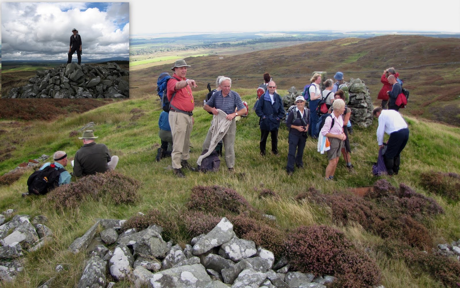
Walks can be found here Pickering Beacon

After meeting up with the group,and members of our own group we set off.Because of the lateness of the day the walk would be cut short.

It didn't take long before we were all chatting along as if we were old friends...it might have been that Lancashire playwright Colin Welland that stated "Yorkshire people are real people"
The weather stayed fairly kind to us until we were above Old Hall farm and the rain became persistent.Luckily we'd almost completed what we'd planned.
Making a wish at the Queen Mary Bridge, Minnigaff

Crossing the King George V Suspension Bridge

A wet finish to the day,but these folk were all still very upbeat.
There'd be no stars to see tonight either.

From what we were told when next meeting the group,on Tuesday they'd managed to climb up to the dyke that runs up to the summit of Benyellery when the weather again turned nasty.Not only rain,but high winds made their guide prudently decide to abandon the rest of the climb.They were quite awed by the views that they did manage to see.

Wednesday the 15th of September.
Todays walk with the group (Including five of our own),is the popular three hills walk from Kirkdale Bridge to Skyreburn.
31st of July Walk

Climbing Barholm Hill

Views from Barholm

Climbing and reaching Ben John

Ben John views

Lunch on Ben John

Ben John Descent

Grass of Parnassus ?

Mill Knock Ascent

View from Mill Knock (Large drystone wall to cross)

Panorama of The Fleet Estuary from Mill Knock on CleVR.com


A steep and slippery descent from Mill Knock

Various ways to cross the burn at Lagganmullan !

Stone Triangle

Skyre Burn Tributary

This walk went beautifully despite some inclement weather to begin with.

As with our own group the good folk from Pickering have their own 'Characters' and the quieter ones.
Having resided in the northern half of England for a great many years,as had some of the others,we had lots in common and plenty to talk about.
A visit to Cairn Holy with the visitors concluded my day.Hopefully they got a good look at the stars later.

A trip down to the North York Moors in 2011 is looking good.

Here's hoping you had a good run through the Galloway Forest Park on your way home folks.
Cheerio the noo.

Added the 19th of September

A few pictures from my good friend Scoop.I'm in these !


Sunday, 12 September 2010

Wigtownshire Ramblers-Culvennan Fell

It's Saturday the 11th of September 2010.
Todays walk is a new one.It's a circular taking in Culvennan Fell north of Kirkcowan.It's in an area not far from civilisation,but somehow remote because of the rugged terrain.

There are twenty of us as we park the cars just north of the A75 on the three lochs road.Showers are forecast,but it looks good at the moment.

A short distance south.I think the farmer had the right idea if the spacing between the words had been greater distances.
Now we leave the tarmac and take to the route of an old Military road to the east.
These ruins must have been a stopping off place.

This from heritagepaths.co.uk
This is part of a fascinating military road that was built by Major Caulfeild in the 1760s. The road originally stretched 105 miles from Bridge of Sark to Portpatrick and much of the old road is under the A75. There is a far larger section* from Ardachie into Glenluce that is not under the A75, but that is not as easy to find anymore, so this is the only part known to be readily walkable.

Unlike all other military roads built in this period, this road was not built for the Hanovarians to gain advantage over the Jacobites but to aid troop movements to Ireland. Roads existed here before the military road was built, so what happened was that those roads were reconstructed and realigned in places. Indeed it has been suggested that much of this road followed a Roman road.


At Ardachie farm the road veers in a north easterly direction.

After a couple of kilometres or so we cross the Carseriggan road into the Mark plantation and take a look at Shennanton House.It's a grade A listed building dating back to 1908,and can be hired out.A short 3 day break for just over £4000 isn't a bad price if there are enough of you.

I spoke to a man who was heading into the woods with a camouflage platform hoping to bag some venison for supper.
Interested ? take a look here
Shennanton

We continue rounding the Shennanton estate passing this old galvanised aeroplane shelter and the Mark of Shennanton Steading.This is another listed building,the technical details are here Mark of Shennanton

Reaching the River Bladnoch we take to the fields north.It's still quite cloudy,but when the sun does come out it's very warm.
Some of the Galloway Hills are still under cloud.

We were watched carefully through this field of prime stock.We also watched carefully!

I've been around of this stretch of the Bladnoch before.I'd been looking for the confluence of the Black Burn and the Bladnoch.Ring of Barfad

Much of todays walk meant negotiating swollen burns.Shorty, our walk leader today, is at pains to insist they weren't like this on the recce...

...Just look at the length of his legs !

I assume the farmer uses these vessels for animal feed.I remember seeing cast iron pots like this in my youth.The foundry at the rear of John White and Sons,Auchtermuchty where I worked had cast vessels of all shapes and sizes.Contrary to popular belief, amazingly we still have a few foundries in Scotland.

Now we're leaving the river towards Carsbuie.A frisky herd of young steers provide a Western touch as they re-enact a scene from Rawhide for us.

Crossing the tarmac road,we take a muddy track through Stony Park plantation.Now into open countryside it's nearly time for lunch.

We're overlooking Barfad Loch.
Beyond the boathouse is an enclosure that needs further investigation....

...it's a site of pilgrimage and probably a lasting memorial to someone.
The large stone in the middle has what may be a font carved into it,and there were a couple of wreaths underfoot.Very intriguing.

Lunch over and we head north of the loch.

Heading west we join what once was a fairly substantial road judging by the stone underfoot.
We're rounding Killymuck (coille nam muc = the wood of the pigs) hill here.

Crossing obstacles has been quite a feature of todays walk.There's more to come !

A dead slow-worm with half it's body missing is found.Chief suspects would be a buzzard or a pine marten.

Now we reach the ruins of a farmstead at Shennock.
Our walk leader recounts an anecdote from working around here some time back.
Now we begin a steady climb through forestry.

We emerge onto Culvennan Fell and a beautiful view over to Wigtown Bay.

A short climb takes us to the trig point.

At 214 Metres,this is the highest point in the Machars.It's only 700 feet but there are some great views from here.


Landmarks are identified and pointed out....

...over to the south-west the Mull of Galloway and Knock Fell (our walk in a fortnight) are bathed in sunshine.

After an enjoyable break we begin a zig zag descent.

Above is a collage of pictures from my last venture onto these fells.There's an abundance of drystone enclosures around here.

Here we come across what appears to be Neolithic burial cairns,much the same as can be seen at Cairnholy.There appears to be a lot of stuff around these fells not documented.I think a good metal detector might turn up some really exciting finds.

Now we're heading over the interestingly sounding Haw Hill with Culvennan Fell behind us.
Down below Haw Hill is somewhere needing more exploration,it's the ruins of a township called Crunlae.

A narrowish deepish burn is the last obstacle on todays walk...

....it didn't exactly go to plan.
Faces have been obscured to prevent embarrassment.Ha ha

It's been a very good and interesting walk.I'll certainly be doing some more exploration round here.
As usual the company was the best....with the exception of the following trespasser.It had attached itself to my right underarm.

Serves me right I suppose.
I'd been badgering the ladies when the call of nature came,to watch out for the little blighters.
Related Posts Plugin for WordPress, Blogger...

Photographs

Creative Commons License
This work is licenced under a Creative Commons Licence.

Morning deer

Morning deer
is someone watching me